
Cedar Park, Philadelphia
Cedar Park | |
|---|---|
 Home in Cedar Park | |
 Cedar Park | |
| Coordinates: 39°56′49″N 75°12′58″W / 39.947°N 75.216°W | |
| Country | |
| State | Pennsylvania |
| County | Philadelphia |
| City | Philadelphia |
| Area code(s) | 215, 267, and 445 |
Cedar Park is a neighborhood of Philadelphia, Pennsylvania, United States. Located in the larger West Philadelphia district, it stretches north to Larchwood Avenue, south to Kingsessing Avenue, east to 46th Street, and west to 52nd Street.[1][2]
History
[edit]Originally outlying farmland, Cedar Park was built between 1850 and 1910 as a streetcar suburb[3] of Center City. Its development as a suburb accelerated with the installation of horsecars in the 1850s and again with the arrival of electric trolley lines in 1892.[4]
The name of the neighborhood is derived from a city owned park, also called Cedar Park, that is at 50th Street and Baltimore Avenue. The land was purchased by the city in 1908 and a city ordinance was signed into law in 1911 declaring it Cedar Park. There is no official explanation as to the name, but it may have been derived from the Cedar Avenue Improvement Organization, who led efforts into ensuring there was a park.[5]
The neighborhood is racially and ethnically diverse, and much of the historic Queen Anne-style architecture still stands.
Since circa 2000, the neighborhood has been undergoing gentrification, stimulated by the University of Pennsylvania's redevelopment plan for West Philadelphia. There is a distinct progressive-politics mien to the neighborhood and a sizable African immigrant community located along and near Baltimore Avenue between 46th and 49th Streets. Cedar Park's residents are predominantly Jamaican/Caribbean and African immigrants, but many are African American (American-born blacks) or white.[citation needed]
Demographics
[edit]As of the 2020 Census, there were 8,752 people residing in Cedar Park. The racial composition of the neighborhood was 52.6% White alone, 31.0% Black alone, 5.4% Asian alone, 0.3% American Indian and Alaska Native alone, 2.0% some other race, and 8.7% multiracial. 7.1% of residents were Hispanic or Latino.[6]
Education
[edit]The neighborhood is host to Saint Francis de Sales School, a private, Catholic School located in the St. Francis De Sales Church at 47th Street and Springfield Avenue.[7] The School District of Philadelphia operates Henry C. Lea Elementary School just outside the neighborhood at 47th Street and Locust street.[8]
Public Transit
[edit]SEPTA services the neighborhood with bus routes, two subway-surface lines (colloquially known as trolley lines), and one regional rail stop along the Media/Wawa Line.[9] The regional rail stop is 49th Street Station, located at 49th Street and Chester Avenue.
Bus Routes
[edit]Trolley Lines
[edit]Gallery
[edit]-
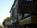 47th Street and Baltimore Ave
 -
 Queen Anne-style rooftops
 -
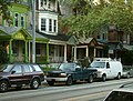 Houses on Baltimore Ave
 -
 Rowhouses on 48th Street between Cedar and Walton Streets
 -
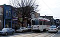 SEPTA'S Route 34 trolley in the 4500 block of Baltimore Avenue


See also
[edit]External links
[edit]References
[edit]- ^ "Philadelphia Neighborhoods". 28 September 2022.
- ^ "Cedar Park Neighbors". Cedar Park Neighbors.
- ^ West Philadelphia Streetcar Suburb Historic District, UCHS Archived 2007-06-04 at the Wayback Machine
- ^ "Studio 34's Eponymous Trolley, or, A Short History of Route 34". Studio 34 Yoga. Archived from the original on April 25, 2012. Retrieved May 10, 2012.
- ^ "Origins of the Namesake Park". Cedar Park Neighbors. Retrieved 2024-10-10.
- ^ "Explore Census Data". data.census.gov. Retrieved 2024-10-10.
- ^ "Who We Are". Saint Francis de Sales School. Retrieved 2024-10-10.
- ^ "Henry C. Lea School – The School District of Philadelphia". Retrieved 2024-10-10.
- ^ "Southeastern Pennsylvania Transportation Authority | Serving Bucks, Chester, Delaware, Montgomery, and Philadelphia counties". www.septa.org. Retrieved 2024-10-10.