Libramont-Chevigny
Appearance
Libramont-Chevigny
Libråmont (Walloon) | |
|---|---|
 The new church in Libramont | |
| Coordinates: 49°55′N 05°23′E / 49.917°N 5.383°E | |
| Country | |
| Community | French Community |
| Region | Wallonia |
| Province | Luxembourg |
| Arrondissement | Neufchâteau |
| Government | |
| • Mayor | Laurence Crucifix |
| • Governing party/ies | Chevi2018 (MR) LIBR'envol (DéFI/PS) |
| Area | |
| • Total | 179.21 km2 (69.19 sq mi) |
| Population (2018-01-01)[1] | |
| • Total | 11,186 |
| • Density | 62/km2 (160/sq mi) |
| Postal codes | 6800 |
| NIS code | 84077 |
| Area codes | 061 |
| Website | libramont-chevigny.be |
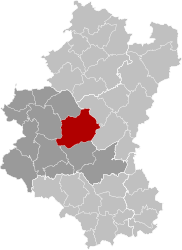
Libramont-Chevigny (French pronunciation: [libʁamɔ̃ ʃəviɲi]; Walloon: Libråmont) is a municipality of Wallonia located in the province of Luxembourg, Belgium.
On 1 February 2015, the municipality, which covers 177.86 km2, had 10,955 inhabitants, giving a population density of 61,59 inhabitants per km2.
The municipality consists of the following districts: Bras, Freux, Libramont, Moircy, Recogne, Remagne, Sainte-Marie-Chevigny, and Saint-Pierre. Other population centers include:
The Ourthe Occidentale river originates in the municipality of Libramont-Chevigny, near the hamlet of Ourt.
Notable people from Libramont-Chevigny
[edit]- Nade Dieu (born 1973), actress
- Jodie Devos (born 1988), operatic soprano
- Fiona Ferro (born 1997), tennis player
- Guillaume François (born 1990), football player
- Anne-Catherine Gillet (born 1975), operatic soprano
- David Henen (born 1996), football player
- Marie Howet (1897–1984), expressionist painter
- Françoise Lalande (born 1941), writer
- Arnaud de Lie (born 2002), cyclist
See also
[edit]References
[edit]- ^ "Wettelijke Bevolking per gemeente op 1 januari 2018". Statbel. Retrieved 9 March 2019.
External links
[edit] Media related to Libramont-Chevigny at Wikimedia Commons
- Official website
 (in French)


