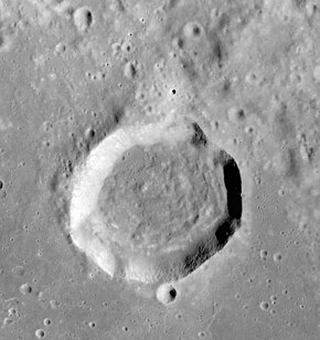
Vitruvius (crater)
 | |
| Coordinates | 17°36′N 31°18′E / 17.6°N 31.3°E |
|---|---|
| Diameter | 30 km |
| Depth | 1.5 km |
| Colongitude | 329° at sunrise |
| Eponym | Marcus Vitruvius Pollio |


Vitruvius is a small lunar impact crater that lies on the northern edge of the Mare Tranquillitatis. To the east is the crater Gardner, and to the northeast is Fabbroni. To the north-northwest is the elongated Mons Vitruvius mountain, and beyond is the valley where the Apollo 17 mission landed.
The rim of Vitruvius is somewhat circular, but the sides are uneven to the north and east. The rim is highest to the northwest. The interior floor is uneven, with some low rises in the southwest. A small crater is attached to southern outer rim. The surroundings grow more rugged to the north of the crater. The crater was named after the ancient Roman engineer and architect Vitruvius.[1]
Vitruvius is a crater of Upper (Late) Imbrian age.[2]
Satellite craters
[edit]By convention, these features are identified on lunar maps by placing the letter on the side of the crater midpoint that is closest to Vitruvius.[3]
| Vitruvius | Latitude | Longitude | Diameter |
|---|---|---|---|
| B | 16.4° N | 33.0° E | 18 km |
| G | 13.9° N | 34.6° E | 6 km |
| H | 16.4° N | 33.9° E | 22 km |
| L | 19.0° N | 30.7° E | 6 km |
| M | 16.1° N | 31.5° E | 5 km |
| T | 17.1° N | 33.2° E | 15 km |
The following craters have been renamed by the IAU.
- Vitruvius A — See Gardner (crater).
- Vitruvius E — See Fabbroni (crater).
Vitruvius G is named El Greco on Lunar Topographic Orthophotomap LTO-61A1 Cajal, but this name was not approved by the IAU.
References
[edit]- ^ "Vitruvius (crater)". Gazetteer of Planetary Nomenclature. USGS Astrogeology Research Program.
- ^ The geologic history of the Moon. USGS Professional Paper 1348. By Don E. Wilhelms, John F. McCauley, and Newell J. Trask. U.S. Government Printing Office, Washington: 1987. Table 11.2.
- ^ Bussey, B.; Spudis, P. (2004). The Clementine Atlas of the Moon. New York: Cambridge University Press. ISBN 0-521-81528-2.
- Andersson, L. E.; Whitaker, E. A. (1982). NASA Catalogue of Lunar Nomenclature. NASA RP-1097.
- Cocks, Elijah E.; Cocks, Josiah C. (1995). Who's Who on the Moon: A Biographical Dictionary of Lunar Nomenclature. Tudor Publishers. ISBN 978-0-936389-27-1.
- McDowell, Jonathan (July 15, 2007). "Lunar Nomenclature". Jonathan's Space Report. Retrieved 2007-10-24.
- Menzel; Minnaert, M.; Levin, B.; Dollfus, A.; Bell, B. (1971). "Report on Lunar Nomenclature by the Working Group of Commission 17 of the IAU". Space Science Reviews. 12 (2): 136–186. Bibcode:1971SSRv...12..136M. doi:10.1007/BF00171763. S2CID 122125855.
- Moore, Patrick (2001). On the Moon. Sterling Publishing Co. ISBN 978-0-304-35469-6.
- Price, Fred W. (1988). The Moon Observer's Handbook. Cambridge University Press. ISBN 978-0-521-33500-3.
- Rükl, Antonín (1990). Atlas of the Moon. Kalmbach Books. ISBN 978-0-913135-17-4.
- Webb, Rev. T. W. (1962). Celestial Objects for Common Telescopes (6th revised ed.). Dover. ISBN 978-0-486-20917-3.
- Whitaker, Ewen A. (1999). Mapping and Naming the Moon. Cambridge University Press. ISBN 978-0-521-62248-6.
- Wlasuk, Peter T. (2000). Observing the Moon. Springer. ISBN 978-1-85233-193-1.
External links
[edit]- Wood, Chuck (August 16, 2004). "Megadome". Lunar Photo of the Day. Retrieved September 27, 2017. - also featuring the surrounding craters including Vitruvius
- "A New Fault". Lunar Photo of the Day. October 22, 2007. Archived from the original on June 14, 2011.
